Category:Chapelle de Faubouloin
Jump to navigation
Jump to search

| Object location | | View all coordinates using: OpenStreetMap - Google Earth - Proximityrama |
|---|
|
This building is indexed in the Base Mérimée, a database of architectural heritage maintained by the French Ministry of Culture, under the reference IA00002188
|
chapel located in Nièvre, in France .jpg) | |||
| Upload media | |||
| Instance of | chapel | ||
|---|---|---|---|
| Location | Corancy, canton of Château-Chinon, arrondissement of Château-Chinon, Nièvre, Bourgogne-Franche-Comté, France | ||
| Architectural style | |||
| Heritage designation | |||

| |||
| |||
Media in category "Chapelle de Faubouloin"
The following 12 files are in this category, out of 12 total.
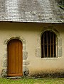
.jpg/120px-Chapelle_de_Faubouloin_(Corancy).jpg) Chapelle de Faubouloin (Corancy).jpg 3,072 × 2,304; 2.71 MB
Chapelle de Faubouloin (Corancy).jpg 3,072 × 2,304; 2.71 MB
 Chapelle de Faubouloin-6048.jpg 3,624 × 6,000; 27.33 MB
 Chapelle de Faubouloin-6049.jpg 4,000 × 5,301; 21.06 MB
 Chapelle de Faubouloin-6050.jpg 4,319 × 3,320; 12.82 MB
 Chapelle de Faubouloin-6062.jpg 4,962 × 3,316; 14.46 MB
 Chapelle de Faubouloin-6067-HDR.jpg 5,984 × 3,989; 20.49 MB
 Chapelle de Faubouloin-6131.jpg 6,000 × 4,000; 20.05 MB
.jpg/120px-Corancy-2576_(02).jpg) Corancy-2576 (02).jpg 5,040 × 4,000; 11.15 MB
Corancy-2576 (02).jpg 5,040 × 4,000; 11.15 MB
 Fontaine du Frêne - Chapelle de Faubouloin.jpg 3,072 × 2,304; 2.02 MB
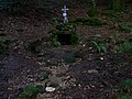
 Fontaine Sainte-Marguerite - Chapelle de Faubouloin.jpg 3,072 × 2,304; 2.57 MB
 Fontaine Sainte-Marie - Chapelle de Faubouloin.jpg 3,072 × 2,304; 1.71 MB
 Tilleul de la Chapelle de Faubouloin.jpg 2,304 × 3,072; 3.1 MB


.jpg)


